Showing posts with label maps. Show all posts

Monday, July 11, 2022

Prudent Street in Maps

Beaudry Street, named for the Beaudry brothers, still exists.

Victor Street, named for Victor Beaudry, still exists (although it was bisected by the 101 long ago).

Victor Heights, also named for Victor, still exists (although it tends to get lumped in with Echo Park). 

There is no street named for Prudent Beaudry specifically.

Anymore, that is. There was a Prudent Street!

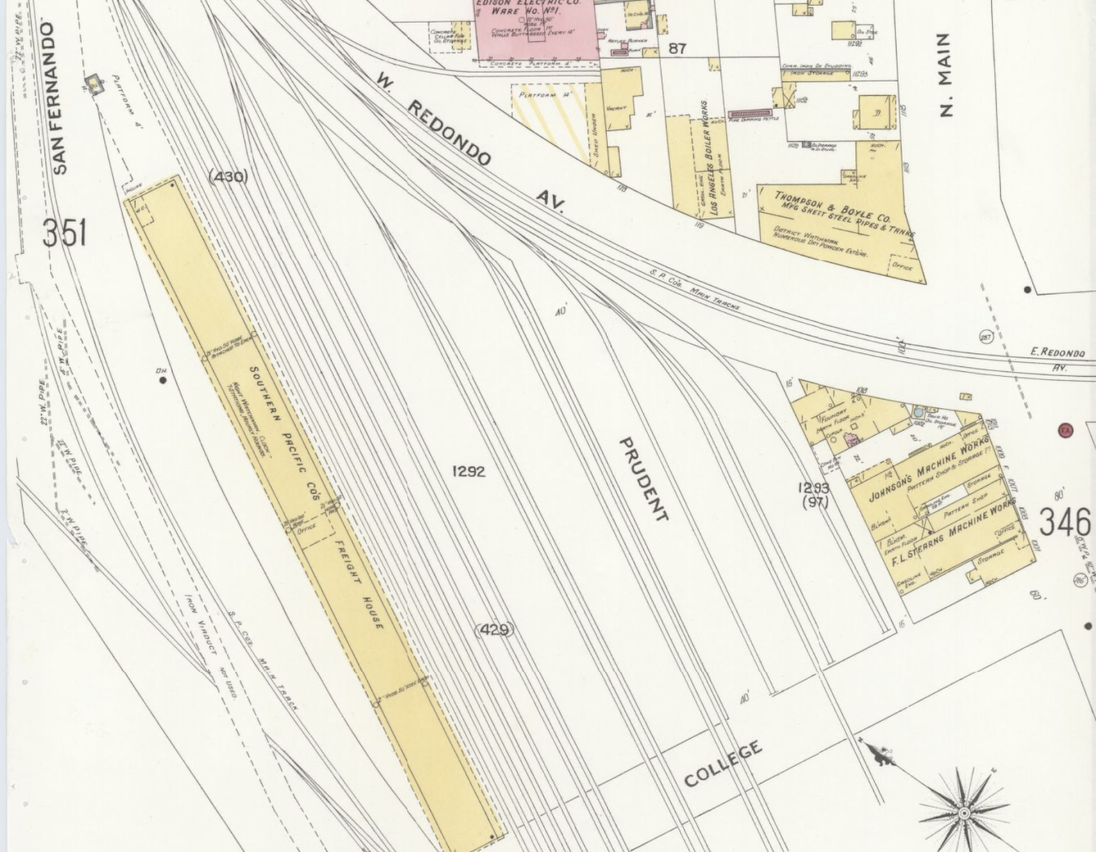
1894 Sanborn map showing Prudent Street

1906 Sanborn map showing Prudent Street

1920 Sanborn map key detail showing Prudent Street

Sanborn map revised 1923, showing Prudent Street


Sanborn Map republished 1953, still showing Prudent Street

A 1950 atlas page that is unfortunately too blurry to post here indicates that Prudent Street was close to Naud Junction, the Bauchet Tract, and the elusive (because the street grid is gone) Ballesteros Tract.

So Prudent Street did exist, and no longer does. Where did it go?

As shown above, railroad tracks and freight houses were built right alongside Prudent Street. A 1912 news article notes the Southern Pacific Railroad applied for permits to legalize 18 existing railroad spurs. All of the spurs were either on Prudent Street or in its immediate vicinity.

Before the railroad came to this part of LA, it was residential. Two news blurbs from the 1880s reference people who lived on Prudent Street.

Those Southern Pacific spurs are lost to time now, Union Station having made them redundant. As for Prudent Street, its site is currently a big dirt lot near Metro's Chinatown Station.

Sunday, October 10, 2021

Erasing Frenchtown in Maps

I have been mapping historic French LA for 8.5 years.

It's harder than it looks. Among the many, MANY changes to the street grid, the intersection of Alameda and Aliso was erased, with Aliso rerouted into Commercial at Alameda Street in the 1950s to accommodate the 101 Freeway.

I get a lot of questions about this, and I think it's easier to explain with maps.

Aliso Street always had a bend in it - now it's more of a long diagonal. Here we see, from top to bottom, Main, Los Angeles, and Alameda Streets intersecting with Aliso. This is from 1894.

Alameda and Aliso streets, 1894

As you can see, Aliso and Commercial Streets are still parallel (and would be for about another 60 years), and Frenchtown still had plenty of houses.

Map showing Alameda, Aliso, and Commercial Streets, 1894.

This 1894 map detail shows the Maier and Zobelein brewery, formerly the El Aliso winery, in the bottom left corner. By this point, Jean-Louis Vignes' vineyard (formerly ground zero for the French community in LA) had been thoroughly developed into a mostly-residential neighborhood, and was still full of French residents like the Ducommuns, the Lazards, and Joseph Mascarel (who died in his Lazard Street home just a few years after this map was made). Maier and Zobelein was rebranded as Brew 102 in the 1940s, with the brewery tanks easily visible from the freeway and in photos.

Zoom in and you can see that Ducommun Street (misspelled here as "Ducummen") and Lazard Street were once two separate streets. Today, it's all Ducommun and it no longer reaches all the way to Alameda Street.

Alameda, Aliso, Commercial, Vignes, Lazard, and Ducommun Streets

Republished in 1923, this map detail shows Aliso and Commercial are still parallel. Lazard Street is now Ducommun, which may be related to the fact that Ducommun Industries was, by then, headquartered along Ducommun Street (a bus parking facility now occupies the old Ducommun Yard).

Alameda, Aliso, Commercial, and Ducommun Streets

North of Aliso, Marchesseault, Apablaza, Napier, and Juan Streets still existed in 1923, although multiple corrections to this map (originally published in 1906) show Old Chinatown/Little Paree gradually being torn down. Today, this is Union Station, the Metropolitan Water District, a park, and (what else...) a parking lot.


This revision, added in December 1937, shows Union Station in place of Old Chinatown/Little Paree, and shows the rerouting of Bauchet Street and the disappearance of Marchesseault Street (renamed East Sunset Boulevard). A local Chinatown historian once told me that if you could walk Marchesseault Street today, you'd more or less be walking into Union Station's front door.


Venturing northeast to where Frenchtown, the Plaza, and Old Chinatown formerly collided, we can see that Sanchez Street used to be longer. The Jennette Block, which housed the Hotel du Lion d'Or and the Hotel de Paris at different times, is now gone, along with the western wing of the Garnier Block. (The Garnier Block houses the Chinese American Museum, and ironically now needs to be expanded because too much of the building was lopped off in 1953 and the Museum needs more space. Oh, the irony.) Note that the Pico House is still called the National Hotel here.


This map is from 1953. Here we see one-third of Sanchez Street missing - lost to the 101 (Hollywood) Freeway. Today, Arcadia Street stands between Sanchez and the freeway and Market no longer exists. Look for the words "being dismantled" - much of what is still shown was gone within five years. 


One more snippet from 1953 - this is closer to today's street grid, except widening of the freeway bumped this section of Aliso further south. El Aliso (the tree itself, not the winery where it stood) was about where Vignes Street dead-ends at Commercial Street today (and, again, this section is now Commercial Street).


Want to see the current street grid laid out over the old one? Wikimedia’s got you covered. (While I firmly believe that Wikipedia is unreliable and should not be used for serious research, this map corresponds with what you’ll see in old maps of LA.)

When the original street grid has been altered to this extent, mapping French LA is a bigger challenge than everyone thinks it is. On top of that, LA added numbering fairly late. I do still plan to reveal the Great Big Map of French LA someday; I'm just not sure when (or if) I'll ever be "done" enough. 

Thursday, October 7, 2021

The French Hospital in Maps

I've previously covered the French Hospital's long history, so I won't rehash it here. 

The building was originally a two-story adobe, shown here on an 1894 Sanborn Fire Insurance Map: 

Image of French Hospital building footprint on map

The hospital was rebuilt in 1915, to the highest standards of then-modern medicine, under the leadership of Louis Sentous Jr. This time, it had a longer, narrower design:

Footprint of French Hospital, 1953

Another wing was added in 1926.

An expansion was approved in 1985. The wings at the back of the building must have been rebuilt between 1953 and 1985, based on the building's current footprint (and the wood-framed nurses' home has long since disappeared). The building's current owners and operators, Allied Pacific, have kept the historic building and reopened it as an urgent care center.


The building changes...the signage and ownership changes...Jeanne d'Arc vanished from the front lawn...still, the hospital persists.

Up next: mapping the erasure of French LA.